

To find a property owner by address, start with the county assessor or parcel viewer, use the address to resolve the parcel ID, and then verify the ownership record against the county recorder's deed index. The answer may be a person, an LLC, a trust, an estate, or another legal entity. Your label should match what the record actually proves.
That distinction matters. A parcel card can identify the taxpayer or owner of record, but it does not always identify the resident, beneficial owner, or decision-maker. A good lookup produces a source trail and an honest answer tier—not merely a plausible name.
This guide covers public-record research for legitimate business and property research. It is not a title examination or legal advice.
unknown nodeWhich public record tells you who owns a property?
The county assessor, property appraiser, or tax authority is usually the best first stop. Its parcel record commonly connects a street address to a parcel number, owner or taxpayer name, mailing address, assessed value, and land-use description. Field availability varies by jurisdiction.
The county recorder or clerk is the better source for the transfer trail. Its index may expose deeds, releases, liens, and other recorded instruments. Some systems do not support address search at all. King County, Washington, says its recorder index is organized by grantor or grantee name, instrument number, and property-tax parcel number—not street address. Its recommended path is to resolve the address in Parcel Viewer first, then carry the parcel number into the records search (King County Recorder's Office, retrieved August 16, 2026).
That division of labor is a useful default even when your county's interface looks different: parcel system first, recorded documents second.
Step 1: Normalize the address before searching
An exact-looking address can still be wrong for the county database. Unit numbers, directional prefixes, street suffixes, and ZIP codes can change what the search returns.
Start with these fields:
- Street number and name
- Direction, such as N, SE, or W
- Standard street suffix, such as ST, AVE, LN, or RD
- City, state, and ZIP code
- Unit number when the property is a condominium or cooperative
If the full string fails, remove the unit or ZIP and search by street number plus street name. Maricopa County's assessor, for example, tells users to abbreviate street types and try fewer address components when a standard search does not work (Maricopa County Assessor, retrieved August 16, 2026).
Do not treat a fuzzy geocoder result as the ownership answer. Geocoding helps locate an address; the parcel record connects that location to the county's tax and ownership identifiers.
Step 2: Resolve the parcel and capture the complete record
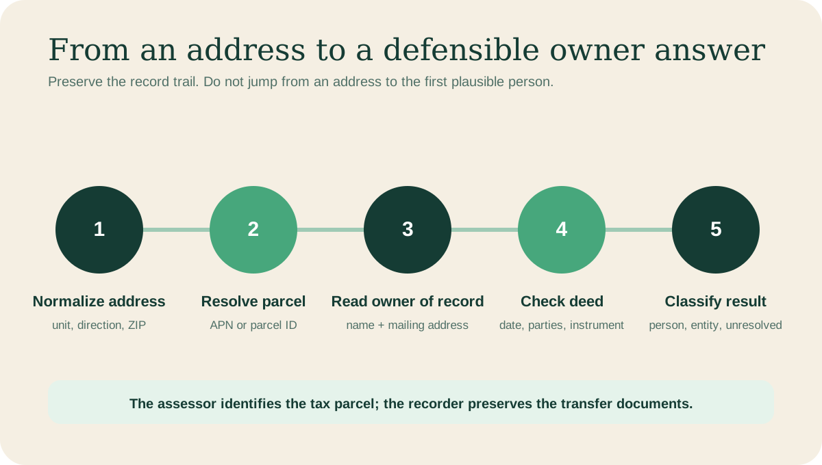
The parcel ID is the bridge between an address search and the documents that show how title changed.
Once you have the parcel, save the record before following individual names. Capture:
- Parcel or assessor's parcel number
- Site address
- Owner or taxpayer name exactly as shown
- Tax-bill mailing address
- Assessed value and use type
- Record update date, tax year, or effective date
- Link or screenshot of the source
The mailing address deserves special attention. A matching site and mailing address can support an owner-occupancy hypothesis. A different mailing address may point to an office, another home, a property manager, or a second entity. It does not settle which one.
County records are not uniform national profiles. Maricopa County's published parcel service includes separate fields for physical address, owner name, and mailing address, while other counties expose fewer fields or use different labels (Maricopa County GIS parcel layer, retrieved August 16, 2026). Preserve the county's terminology instead of silently translating “taxpayer” into “resident.”
Step 3: Verify the current deed or transfer record
The parcel card is a current snapshot; the deed trail explains how the owner got there. Search the recorder using the parcel ID, owner name, or instrument reference supplied by the assessor.
For the apparent current transfer, record:
- Grantor and grantee
- Recording date and, when shown, execution date
- Instrument type
- Instrument or book-and-page number
- Legal description or parcel reference
- Any ownership form written into the deed
A recent sale can appear in the recorder before every downstream tax system has refreshed. The reverse can also happen when an index is difficult to search. If the parcel card and the newest deed conflict, report the conflict and its dates rather than choosing the more convenient answer.
The recorder also warns against overreach. King County says it does not perform title searches or make legal interpretations about recorded documents. For a purchase, dispute, lien question, or other high-stakes matter, use a title professional or attorney rather than a blog workflow.
Step 4: Decide whether the record names a person or an entity
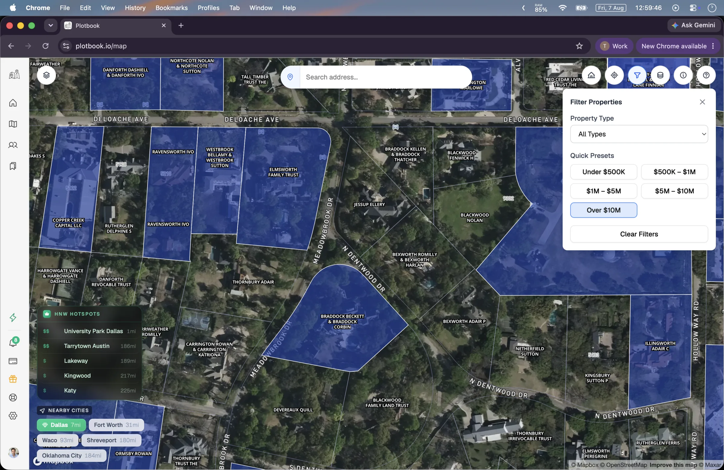
A national parcel layer makes discovery consistent, but the underlying owner name still comes from jurisdictional property data.
Classify the deed owner before you search the web. Common classes include:
- Natural person or joint owners
- Limited liability company or corporation
- Trust
- Estate
- Partnership
- Government, bank, university, church, or other institution
If a person is named, the owner-of-record question may be answered. The resident question is still separate. A rental, second home, family property, or recently transferred home can have different owners and occupants.
If an entity is named, do not replace it with the first human associated with the company. Search the official business registry, record each person's stated role, compare business and tax mailing addresses, and corroborate the result. The complete process is covered in how to find the person behind an LLC-owned property.
Why an LLC search may stop without a person's name
Public company filings do not consistently reveal beneficial owners. A 2026 GAO review found that state filings may collect officers, directors, managers, or members, but those names may not be the beneficial owners or people with substantial control. The extent of public information also varies by state (GAO-26-107967, May 29, 2026).
The federal beneficial-ownership database is not a public property-owner directory. GAO describes it as a secure, nonpublic system available only to authorized government authorities under specified safeguards (GAO-26-108182, June 23, 2026).
That means “entity only” can be the correct public-record answer. A commercial registered agent or law firm should not be promoted to property owner merely because its name appears in a filing.
Use confidence labels instead of one undifferentiated answer
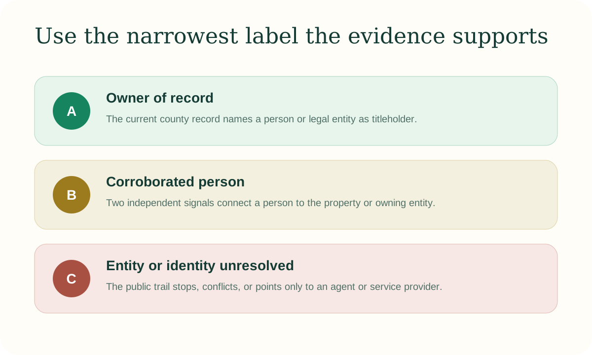
The label should get no broader than the evidence. A useful unknown is better than a confident false match.
Use a small answer taxonomy:
Owner of record. The current parcel or deed record names this person or legal entity as titleholder.
Corroborated person. At least two independent signals connect a natural person to the owning entity or property, and the names, locations, and timeline do not conflict.
Possible association. A filing, mailing address, or professional source creates a reasonable lead, but the connection is not strong enough to state as ownership or occupancy.
Unresolved. The public trail ends, conflicts, or leads only to agents and service providers.
This scheme prevents a common data-quality problem: one “owner” field silently mixing deed owners, residents, relatives, managers, and guessed beneficial owners.
How a nationwide parcel map changes the workflow
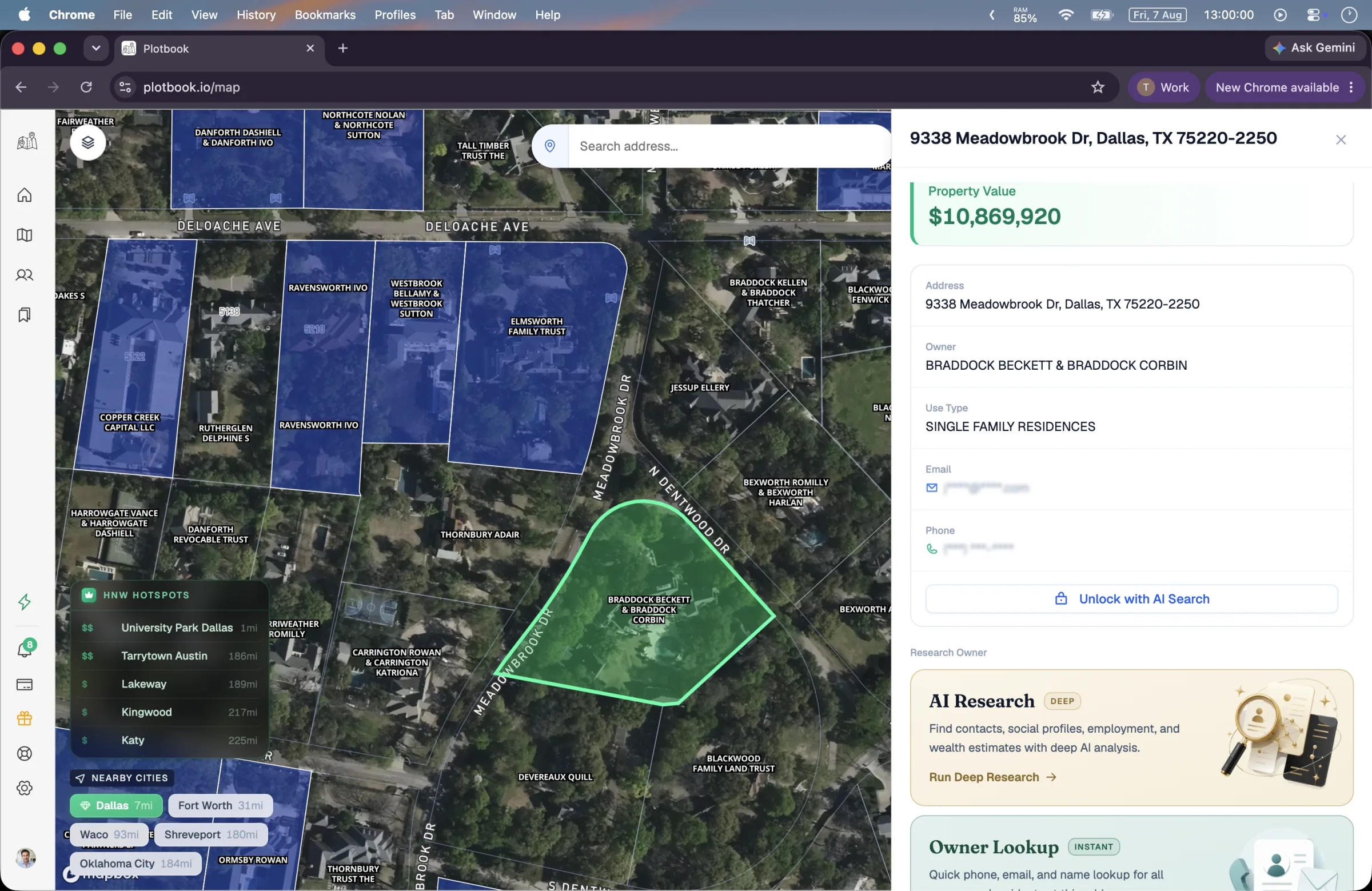
Illustrative Plotbook interface. Product screenshots may contain demo data; the workflow, not the displayed person, is the evidence.
County portals are authoritative for their jurisdictions. The practical cost is that every county has a different interface, field set, and refresh rhythm. A standardized parcel layer lets you search and compare places without learning a new portal for each address.
Regrid says it assembles county-sourced parcel records into a nationwide schema, including owner, site address, mailing address, parcel ID, and assessment information. Its current coverage explorer reports 160 million parcels across more than 3,200 counties, while Plotbook conservatively markets nationwide Regrid parcel data covering 150M+ parcels (Regrid coverage explorer, retrieved August 16, 2026).
In Plotbook, the actual flow is map → parcel → property drawer. The deed owner and assessed value are part of map browsing. If the deed names a person, the instant Owner Lookup can return owners and residents with available contact details from a licensed US consumer-records provider. If the deed names an LLC, trust, or partnership, the drawer offers deep AI owner research.
Coverage varies by person and county. Neither path guarantees a natural-person answer.
The field workflow is the same on an iPhone
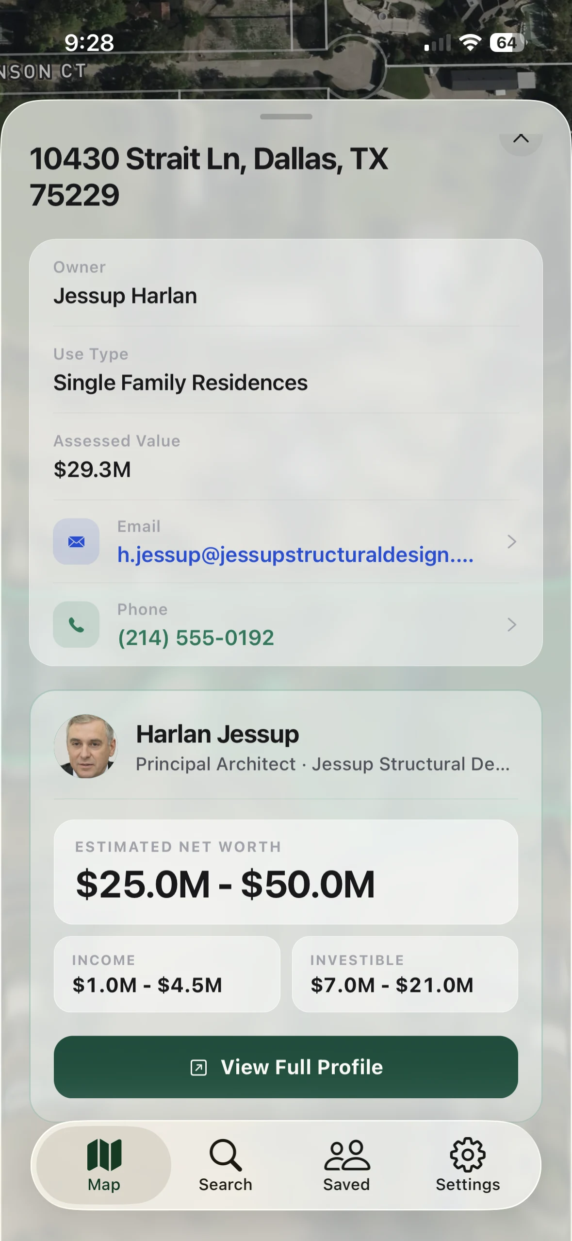
Plotbook for iPhone carries the parcel-to-profile workflow into the field. The screenshot is illustrative and may contain demo data.
An address lookup does not have to begin at a desk. Plotbook for iPhone lets a subscriber tap a parcel, read the owner of record and assessed value, and start research from the field. Deep research continues in the background and can send a push notification when it finishes.
The important product boundary remains the same: the map is a discovery and research layer. It does not send outreach, dial a number, or make a compliance decision for the user.
What a property-owner lookup does not prove
A completed lookup does not automatically prove:
- Who currently occupies the property
- Whether spouses, partners, or relatives share an ownership interest
- The beneficial owner of every entity or trust
- Current market value, mortgage balance, equity, or investible assets
- That a phone number or email is appropriate for a particular outreach use
- That the person is a suitable client or eligible for a financial product
Property value is one prioritization signal. For the financial distinction between assessed value, assets, net worth, and investible wealth, see why a net worth estimate should be a range.
Before using contact data, follow your firm's supervisory process and the laws that apply to the channel and jurisdiction. Research permission and outreach permission are not the same thing.
A repeatable owner-lookup checklist
Use this checklist for every address:
- Normalize the address and confirm the pin is on the intended structure.
- Resolve the parcel ID in the assessor or parcel viewer.
- Save the exact owner name, mailing address, value, use type, source, and date.
- Open the recorder index and verify the apparent current transfer.
- Classify the owner as a person, entity, trust, estate, partnership, or institution.
- If needed, follow the relevant entity-research path without relabeling roles.
- Corroborate natural-person matches across independent sources.
- Label the result by confidence and keep unresolved conflicts visible.
- Separate property discovery from wealth estimation and outreach approval.
- Save the record so another researcher can reproduce it.
For a territory-scale version of this process, compare property-first and list-first prospecting.
Frequently Asked Questions
Can I find a property owner for free?
Often, yes. Many county assessors or parcel viewers provide a public address search, and recorders provide an index of recorded documents. Interfaces, fees for document images, update dates, and fields vary. Start with the official county site and verify that you are on a government domain.
Is the taxpayer name always the legal owner?
Not necessarily. A taxpayer or tax-bill recipient can be useful, but the label and local system matter. Verify the current deed when the distinction is important, and preserve any discrepancy between the tax record and recorder.
Does the deed tell me who lives at the address?
No. A deed identifies the legal titleholder. The occupant may be the owner, a tenant, a relative, or nobody at all. Residential lookup data may suggest occupants, but it should remain role-labeled and dated.
What if the property is owned by a trust or LLC?
Keep the trust or LLC as the owner of record. Then use the correct research path for that entity type. Public sources may reveal a trustee, manager, member, officer, mailing address, or related person, but not every role proves beneficial ownership.
Is assessed value the same as market value?
No. Assessed value is created for property-tax administration under local rules. It may be a useful screening field, but it is not automatically a current appraisal, sale price, equity figure, or measure of liquid wealth.
The goal is a reproducible answer
Finding a property owner by address is not difficult because the first search box is hidden. It is difficult because “owner” can refer to several different roles, and the records update on different schedules.
Use the address to resolve the parcel. Use the parcel to find the ownership record. Use the deed to verify the transfer. When a company or trust appears, follow that trail without pretending every associated person is the owner.
Plotbook puts the parcel, owner-of-record field, instant household lookup, and deep entity research into one workflow. Start with the property wealth map, then keep the same source discipline you would use in the county systems.